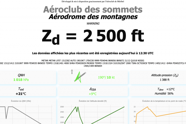
Altitude density is an essential parameter in flight preparation, especially when it is high. It directly influences aircraft performance, particularly during takeoff and landing. Density altitude increases with altitude and temperature, thereby reducing performance. In order to improve its members' awareness of the situation, the Méribel flying club, which is particularly concerned as it is located at 5640 ft, has developed a tool for measuring and displaying density altitude in real time in the club's premises.
To facilitate the display of density altitude in club premises located at aerodromes equipped with aeronautical meteorological information (METAR), the flying club has developed a tool that retrieves METAR data and displays it on the web page hosted by the club's website or on the club's Smile TV FFA!
This document explains how to set up this altitude-density display using METAR data. The entire system was designed and developed on a voluntary basis by the Méribel flying club and is available free of charge to clubs on Github (METAR-to-ZD. This project can be set up quickly and only takes a few hours; it costs nothing to the flying club that implements it.